![]()
The Route Briefing function only works with DynCorp DUATS. You can get a route briefing from DTC DUATS, but you will need to navigate on your own to collect the briefing.
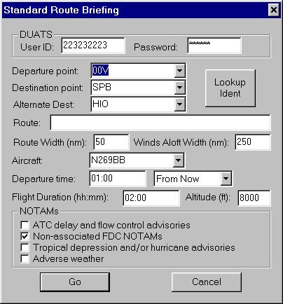
The route briefing screen collects a Low-Altitude Route briefing from Dyncorp DUATS.
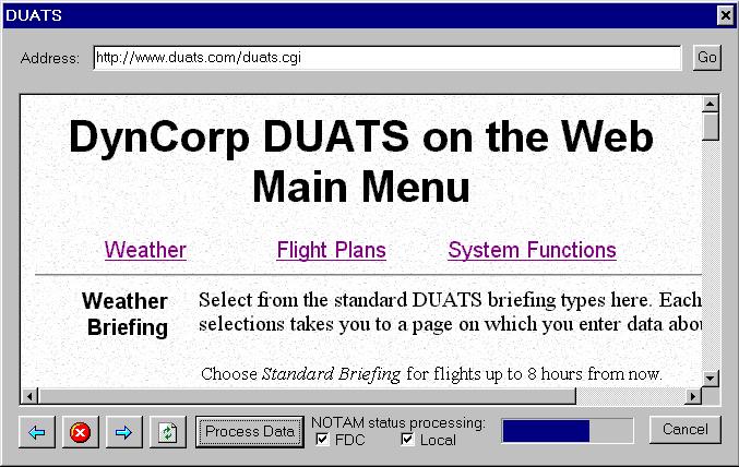
This screen is displayed after you select Area Briefing, Route Briefing, or Generic web access. If you have selected Area or Route Briefing, NOTAM Tracker will automatically navigate the DynCorp Web page to get to your briefing. If you have selected Generic Web accesss, you will need to navigate, just as you would with a web browser, until the briefing is displayed on the screen. Then press the "Process Data" button.
This screen is displays the results of NOTAM Tracker's analysis. NOTAMs that are new since the last time you ran NOTAM Tracker will be highlighted in green. NOTAM's you've already seen, as well as the weather briefing from DUATS, will be in blue. NOTAMs that have been deleted will be shown in struck-out in brown. An index of all new notams, deleted notams, TFRs, obstructions and waypoint coordinates found in the briefing is displayed at the bottom of the screen, allowing quick review of any changes.
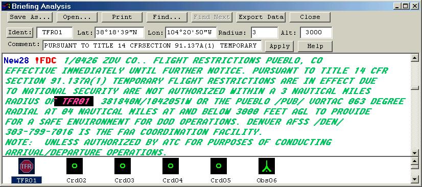
At the bottom of this window is an index of all of the waypoints, TFRs, coordinates, new local NOTAMs, new FDC notams, and deleted (dead) NOTAMs Tracker has found in your briefing. You can click on any of them to automatically scroll to that location in the briefing. Once you have clicked on a TFR/coordinate or obstruction, the top of the screen will show the lat/lon, radius, altitude and comment information NOTAM Tracker has extracted for the that item. Since their is not fixed format for NOTAMs, it is possible NOTAM Tracker will not be able to accurately transcribe every coordinate/altitude/radius. It is your responsiblity to quickly compare the briefing coordinates with NOTAM Tracker's coordinates.
You can also delete individual items by clicking to select them and then pressing the delete key.
Currently only Garmin portable GPS units are supported. To upload coordinates to your GPS, you will need a serial communications cable connecting the GPS to your computer (this is the same cable you'll use to update the firmware/database on your GPS).
First make sure that the communications port that your GPS is connected to is selected on the Setup Screen. On this same screen, make sure that "Coordinate Export Format" is selected to "Upload to Garmin GPS".
Now collect your briefing in the normal manner. To start the uploading, press the "Export Data" button from the Briefing Output screen. Make sure "Upload Coordinate Data" box is selected, your GPS is turned on and connected, and press "Go".
Note that Garmin does not provide a way to remotely delete user waypoints, so there is no way for NOTAM Tracker to remove old TFR's and coordinates. It is recommended that you manually delete these from your GPS as they become obsolete. (You can always just delete all of them - Garmin provides a Delete by Symbol option - since NOTAM Tracker will restore any TFR's that are still in effect anyways).
Note that NOTAM Tracker will overwrite any waypoints with names of TFRnn, CRDnn, or OBSnn where nn is a two-digit number.
The easiest way to export a briefing to your PocketPC is to go the the Setup Screen and make sure "Briefing Export Format" is set to Rich Text. Then, after collecting a briefing, press the "Export Data" button on the Briefing Output screen. Now press the "..." button to browse for your destination folder. If you look in the My Documents folder you will find a folder labelled something like "PocketPC My Documents". If you set the export directory to this directory (or a subfolder), and have "File Synchronization" turned on in MicroSoft's ActiveSync program, then ActiveSync will automatically transfer the new briefing to your PDA every time you press the Export Data button.
White Antelope Systems relies on your registration money to develop programs like NOTAM Tracker. If you think NOTAM Tracker is worth the money, please register it!
Registration is easy. To register your software, click here and following the instructions. Remember, if you ever have any problem with NOTAM Tracker please check our Frequently-Asked-Questions page. If you answer isn't there, email us at custserv@WhiteAntelopeSoftare.com for a prompt resolution. Thanks!
LEGAL NOTICES: DTC, or Data Transformation Corporation, the provider of DUATS service at www.duat.com, is in no way affiliated with White Antelope Systems. DynCorp Information Services LLC, the provider of DUATS service at www.duats.com, is in no way affiliated with White Antelope Systems. NOTAM Tracker acts as a web browser to collect information from these, or other, services. White Antelope Systems and NOTAM Tracker do not provide, and are not responsible for, any information. NOTAM Tracker merely reformats the data provided for more convenient viewing. While NOTAM Tracker attempts to track notams, and search for coordinates within the briefing, the accuracy of such coordinates, radii, and altitudes cannot be gauranteed. It is the pilot's responsibility to review the briefing for completeness, and to check the accuracy of the coordinate translations. Microsoft, ActiveSync, and Windows are registered trademarks of the Microsoft Corporation.